| |||||
It’s
often said that the Korean Demilitarized Zone, or DMZ, is the most dangerous
place on Earth. This distinction is probably technically true - the mountains
and hillsides on both sides of the 4km strip of land separating the two Koreas
bristles with troops, guard posts, tanks, missile, bunkers, gun emplacements,
land mines and other tools of death and destruction. A one-hole golf course at a
military base in Panmunjeom, the truce village that has come to symbolize the
world’s last Cold War frontier, warns not to retrieve balls from a fairway lined
by land mines - once designated as the “world’s most dangerous golf
course.” Yet
the DMZ is perhaps the supreme irony in a land of ironies. As you gaze out upon
the DMZ from Checkpoint 3 of Panmunjeom’s Joint Security Area, your attention is
drawn not to the rare opportunity to peek into mysterious North Korea, the North
Korean soldiers perched on the watchtower nearby, or your chances of survival in
a sudden (and highly unlikely) re-opening of hostilities. Instead, you’re
captivated by the supreme tranquility - the quiet, the lush green hillsides, the
rare birds swooping into untouched marshlands. Here, at the most militarized
border on the planet, you feel completely at peace. Yet
the DMZ is perhaps the supreme irony in a land of ironies. As you gaze out upon
the DMZ from Checkpoint 3 of Panmunjeom’s Joint Security Area, your attention is
drawn not to the rare opportunity to peek into mysterious North Korea, the North
Korean soldiers perched on the watchtower nearby, or your chances of survival in
a sudden (and highly unlikely) re-opening of hostilities. Instead, you’re
captivated by the supreme tranquility - the quiet, the lush green hillsides, the
rare birds swooping into untouched marshlands. Here, at the most militarized
border on the planet, you feel completely at peace. The DMZ stretches some 248 kilometers across the Korean Peninsula from the mouth of the Imjin River in the west to the town of Goseong in the east. The demilitarized zone itself, where human activity has been greatly limited for the last half-century, has become one of Asia’s greatest nature preserves. In the sparsely populated hinterlands just outside the zone, where it seems soldiers outnumber civilians, you can find both towering monuments to battles won and derelict ruins that stand witness to the tragedy of war. No one can properly take in the entire DMZ area over the course of a single weekend, but if you’re in Seoul, the peace village of Panmunjeom, the touching Imjingak park and the beautiful mountains and rivers of Cheorwon offer the traveler a real glimpse of the history and culture of this most uniquely Korean tourist destination. → Find out more! DMZ tours | |||||
| Panmunjeom: Last Cold War Frontier | |||||
| With
the fall of the Berlin Wall, Panmunjeom became the world’s last remaining
outpost where democracy and communism stare at each other in the face in a tense
standoff, pregnant with political and historic meaning. Improved inter-Korean
relations as of late have reduced the atmosphere of tension in Panmunjeom
considerably, but the men standing guard on Freedom’s Frontier, as the DMZ is
called, aren’t taking it easy. Civilians cannot enter the DMZ without prior
permission, and tourists can visit Panmunjeom only as part of organized group
tours. Even then, visitors must follow strict dress codes and, above all, follow
closely the instructions of official guides, who are usually US soldiers.
Tours from Seoul first take you along Freedom Road, the flat and straight highway connecting the capital with the DMZ. The buses eventually reach the Imjingang River, crossed by the Unification Bridge. This is the end of the line for most civilians. If you’re with a tour group, however, you’ll pass through an army checkpoint at the southern end of the bridge and cross into the Civilian Limit Zone and, a bit beyond that, the Joint Security Area, or JSA.  The
first stop on the tour is Camp Bonifas (named after a US soldier who was axed to
death in the JSA in 1974), a large South Korean military installation that
serves as the base camp of the United Nations Command Security Force-Joint
Security Area. For most of post-Korean War history, the southern side of the JSA
was jointly patrolled, but since 2004, it has been entrusted exclusively to the
South Koreans (although a small contingent of Western, mostly American, troops
remain). At the camp, you’ll be briefed (usually by a US officer) on the history
and regulations of the JSA. There, you can also check out the short par-3,
one-hole golf course on the base premises - just don’t expect to retrieve your
golf balls. The
first stop on the tour is Camp Bonifas (named after a US soldier who was axed to
death in the JSA in 1974), a large South Korean military installation that
serves as the base camp of the United Nations Command Security Force-Joint
Security Area. For most of post-Korean War history, the southern side of the JSA
was jointly patrolled, but since 2004, it has been entrusted exclusively to the
South Koreans (although a small contingent of Western, mostly American, troops
remain). At the camp, you’ll be briefed (usually by a US officer) on the history
and regulations of the JSA. There, you can also check out the short par-3,
one-hole golf course on the base premises - just don’t expect to retrieve your
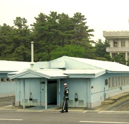
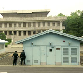
golf balls. It’s another short bus ride to the JSA. About 400 meters past Camp Bonifas, you come to a double-barbed wire fence manned by South Korean soldiers. This fence, which continues almost unbroken for the entire breadth of the Korean Peninsula, marks the start of the DMZ. Pass the fence, and it’s like entering a completely different planet. Vegetation grows lush and, outside the bus, the scenery is eerily peaceful and, frankly, spooky. Some of the land is cultivated by the villagers of Daeseong-dong, the only civilian habitation in the southern half of the DMZ (villagers are given more than $80,000 USD per year and are exempt from taxation and military service). But by and large, the only things that move are the birds - protected from human activity for a half century, the DMZ has become a habitat for many species of wild birds. The Joint Security Area itself is iconic, especially if you’ve seen Park Chan-wook’s 2000 film, “JSA.” This small cluster of buildings - some impressive, some humble - was born in 1953 following the signing of the Armistice Agreement (“ending” the Korean War) in the actual village of Panmunjeom, which was located about 800 meters to the north but has since disappeared. The JSA - widely referred to as “Truce Village” - was used for regular meetings between North Korean and UN military officials (the Military Armistice Committee, or MAC) to supervise the implementation of the armistice. It is now used primarily for inter-Korean meetings.  The
JSA is split down the middle by the Military Demarcation Line (MDL), the actual
“border” between North and South Korea. On the southern side are the impressive
Freedom House and Peace House, which aside from being splendid pieces of modern
Korean architecture, are also used for inter-Korean meetings. On the northern
side of the MDL is the Panmungak, a gray Stalinist structure which, our guides
will point out, is probably smaller than it actually appears. Soldiers from both
sides stare down visitors and each other. Between the two borders is the
sky-blue MAC building built in the 60s, where with a guide, you may briefly
cross over into North Korean territory (permissible ONLY within the building). The
JSA is split down the middle by the Military Demarcation Line (MDL), the actual
“border” between North and South Korea. On the southern side are the impressive
Freedom House and Peace House, which aside from being splendid pieces of modern
Korean architecture, are also used for inter-Korean meetings. On the northern
side of the MDL is the Panmungak, a gray Stalinist structure which, our guides
will point out, is probably smaller than it actually appears. Soldiers from both
sides stare down visitors and each other. Between the two borders is the
sky-blue MAC building built in the 60s, where with a guide, you may briefly
cross over into North Korean territory (permissible ONLY within the building).
Near the buildings is a highpoint called Checkpoint 3. From here, you get a sweeping vista of the DMZ. The tranquility of it all is unnerving. Who’d imagine that surrounding this beautiful stretch of untouched nature is one of the largest concentrations of military force in the history of man? In the near distance, in the North Korean Potemkin village of Kijong-dong, is home to the world’s tallest flag post (160 meters), flying the world’s largest flag. → Find out more! Panmunjeom | |||||
| Imjingak: Shrine to the Displaced | |||||
 If
you’re into traveling alone, or want to forego the Panmunjeom tour, Imjingak is
worth a visit. The closest thing most South Koreans can get to the DMZ without
special permission from the government, the Imjingak is a park overlooking the
Imjingang River - literally a shrine to national division. Major landmarks
include an altar where families originally from the North come to perform
ancestral rites (usually performed in one’s ancestral hometown) on the Korean
holidays, an observatory and Freedom Bridge, the hastily constructed bridge
where some 130,000 South Korean and Allied POWs crossed to return home at the
end of the Korean War. You may also purchase North Korean goods or eat North
Korean food at some of the park’s shops and restaurants. If
you’re into traveling alone, or want to forego the Panmunjeom tour, Imjingak is
worth a visit. The closest thing most South Koreans can get to the DMZ without
special permission from the government, the Imjingak is a park overlooking the
Imjingang River - literally a shrine to national division. Major landmarks
include an altar where families originally from the North come to perform
ancestral rites (usually performed in one’s ancestral hometown) on the Korean
holidays, an observatory and Freedom Bridge, the hastily constructed bridge
where some 130,000 South Korean and Allied POWs crossed to return home at the
end of the Korean War. You may also purchase North Korean goods or eat North
Korean food at some of the park’s shops and restaurants.Getting to Imjingak couldn’t be easier - hourly commuter trains now go directly to Imjingak from Seoul Station. → Find out more! Imjingak | |||||
| Cheorwon: Amidst the Ruins of War | |||||
| More
adventurous souls can also visit the small town of Cheorwon, some two hours
northeast of Seoul. Once a sizable town and major railway stop commanding the
Geumhwa Valley, Cheorwon was literally obliterated during the Korean War -
brutal frontline warfare that earned its name, “The Iron Triangle.” Today, Old
Cheorwon is now either overgrown or has been developed into rice paddies - it’s
never quite recovered although there’s a small downtown built nearby - but there
are a number of inspiring war memorials in the area (especially the obelisk
commemorating the particularly bloody fighting for White Horse Hill) and a few
ruins that testify to the horrors of war and tragedy of national division.
The most notable of these are the ruins of the old Korean Workers Party office. An impressive three-story Soviet-style building made entirely of concrete, the building was built in 1946 - when Cheorwon was under North Korean control - as the regional headquarters of the North Korean ruling party, the Korean Workers Party. Now, only its bullet and shell-scarred exterior remains. Like the burnt-out shells of churches left standing in post-war Germany, these bombed-out ruins are a moving reminder of its shattered past. Another interesting site is Seungil-gyo Bridge, which crosses the Hantangang River several kilometers from the ruins (a short bus ride from the small town of Dongsong-eup). Look carefully, and you’ll notice the two halves of the bridge are different: either North Koreans started building the bridge before the war and South Koreans finished it; or the Japanese started it before Liberation in 1945 and the US Army finished it to transport men and supplies to the front during the war. Even the name is curious: seemingly combining the names of the first presidents of South and North Korea (Rhee Syngman and Kim Il-sung), the bridge was likely named for a South Korean officer, Colonel Park Seung-il, who was killed during the war. Now, somewhat incongruously, the river around the bridge is often used for rafting and other water activities. The easiest way to get to Cheorwon is by subway line 1 to the northern suburb of Dongducheon, where a commuter train takes you to Sintan-ni. From there, it’s another short ride to Cheorwon. → Find out more! Cheorwon
| |||||
| Written and photographed by Robert Koehler The article courtesy of Seoul magazine | |||||
2012년 2월 18일 토요일
The DMZ


피드 구독하기:
댓글 (Atom)
댓글 없음:
댓글 쓰기